
Mezdra
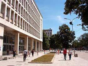 The Mezdra municipality spreads over an area of 554 km2, the most of which is in the defile of the Iskar River. It borders the Vratza, Roman, Byala Slatina, Botevgrad and Svoge municipalities. There are 27 villages in its territory. Situated in a picturesque hollow between the river terraces, at a 270 m of altitude, the town of Mezdra is attractive not only for its rich natural beauty, but for its position as a road and railroad gate to Northwestern Bulgaria.
The first traces of settlement activity date from the 2nd-3rd centuries AD, when the Romans built the "Kaleto" fortress. In the times of the Ottoman invasion in the end of the 14th century most of the villages in the area were wiped out. The survivals sought for refuge in the less accessible vicinities. Mezdra itself existed in the Middle Ages by the name of Torbaritsa - a settlement and a fortress, which were also destroyed in 14th century.
The place remained uninhabited for a long time, hence the name "mezrata" - "an empty and deserted place". It was not until the first half of the 19th century when herdsmen from the nearby villages settled at "Princhovets" locality, 2 km to the West from the present-day town, on the Kamenitsa River. Before the Liberation some 15-20 houses with "gray roofs covered with thin limestone slabs" existed (Felix Kanitz) with a total number of 68 residents. From 1878 on the population moved to the "Selishteto" locality.
 Albena
 Varna
 Gorna Lipnitsa